
中文
-
About ANSO
-
News & Stories
-
Members
-
Events
-
Programs
-
Publications
-
Get Involved
On 27-28 October 2025, the "Technical Training Workshop on Monitoring and Assessment of Water Resources and Agricultural Water Use in North Africa" was successfully held in Tunis, Tunisia. The training was co-hosted by the Aerospace Information Research Institute of Chinese Academy of Sciences (AIR-CAS) and the Sahara and Sahel Observatory (OSS), and supported by a research project of the Alliance of National and International Science Organizations for the Belt and Road Regions (ANSO). The event brought together over 30 representatives from research institutions and government departments in Tunisia and Libya, specializing in areas such as remote sensing, agriculture, and water resources.
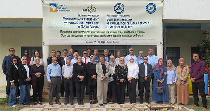
Figure 1. Group photo of the training participants
At the opening ceremony, Mr. Nabil Hamada (Director of Administration and Finance at OSS), Dr. Aïssa Hlaimi (Director General of Water Resources at Tunisia's Ministry of Agriculture and Water Resources), and Prof. Li JIA from AIR-CAS delivered speeches. They emphasized that, as global water scarcity intensifies, it is crucial to strengthen the monitoring and efficient use of agricultural water resources for safeguarding food security and advancing sustainable development in North Africa.
During the training, experts from the EOWater Team of AIR-CAS, including Prof. Li JIA, Associate Prof. Chaolei ZHENG, and Dr. Min JIANG, systematically introduced key technologies such as remote sensing-based evapotranspiration monitoring, estimation of cropland water demand/consumption and productivity, and assessment of cropland water use efficiency. They also presented the ETMonitor remote sensing evapotranspiration model and the Water Resources and Agricultural Water Use Monitoring Platform in Northern Africa (WaterMap N-Africa), developed in-house. Through hands-on exercises, participants gained practical skills in interpreting multi-scale remote sensing products and information for precision water management via the WaterMap N-Africa platform.

Figure 2. On-site guidance and interaction during the training session
This training marked the first time that AIR-CAS and OSS had cooperated in carrying out regional capacity-building activities. Not only did it effectively improve the professional level of remote sensing application and data analysis among the North African participants, but it also facilitated the exchange of cross-field and cross-regional experience, laying a solid foundation for the sustainable utilization of water resources and the sustainable agricultural development in the region.
During the training, Mr. Nabil BEN KHATRA, Executive Secretary of OSS, met with the AIR-CAS research team. Both parties engaged in in-depth discussions on topics such as monitoring techniques of water resources and utilization, high-resolution remote sensing applications, and regional capacity building in North Africa. A consensus was reached on future scientific research cooperation, technology sharing, and institutional capacity improvement, with an agreement to continuously strengthen the partnership. The two parties will collaborate to promote the greater use of remote sensing and digital technologies in agricultural water resources management in North Africa and the Sahel region, thereby providing scientific and technological support for achieving regional sustainable development goals.
Source: Jing LU, Aerospace Information Research Institute, Chinese Academy of Sciences
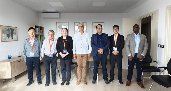
Figure 3. Meeting between the OSS Executive Secretary and the AIRCAS team
The Water Resources and Agricultural Water Use Monitoring Platform in North Africa (WaterMap N-Africa) is a core achievement of the ANSO joint research project "Monitoring and Assessment of Water Resources and Agricultural Water Use in North Africa". Built on satellite remote sensing and cloud computing technologies, it is a key tool for monitoring water resources and agricultural water use in the region. The project is led by Prof. Li JIA at AIR-CAS and involves the joint participation of multiple scientific research institutions in North Africa.

Figure 4. Interface of the WaterMap N-Africa platform for monitoring agricultural water resources and water use in North Africa


 No.16 Lincui Road, Chaoyang District, Beijing, China
 86-10-84097121
 anso-public@anso.org.cn