From November 27 to December 1, 2023, the "Regional Forum on Geospatial Information Applications for Resilient Agriculture in South-East Asia" was successfully held in Kunming, Yunnan. The seminar was co-hosted by the United Nations Economic and Social Commission for Asia and the Pacific (UNESCAP), the Alliance of National and International Science Organizations for the Belt and Road Regions (ANSO), the Aerospace Information Research Institute of the Chinese Academy of Sciences (AIR-CAS), the Geoinformatics and Space Technology Development Agency of Thailand (GISTDA), and the ASEAN Regional Training Center for Space Technology and Applications (ARTSA). It was organized by the School of Ecology and Environmental Science, Yunnan University, with over 40 representatives from UN-related agencies, research institutions, universities, and government departments from China and Southeast Asian countries in attendance. This seminar was also part of the ANSO-supported "Belt and Road" CropWatch Innovation Cooperation Project (CropWatch-ICP) and the National Key R&D Program Intergovernmental International Cooperation Key Special Project under the GEOGLAM framework-Research on Advanced Crop Condition Monitoring Methods with Remote Sensing (CropWatch-GEOGLAM), aiming to develop a series of collaborative resear ch and capacity building activities in crop monitoring for developing countries in South Asia and Southeast Asia.
Enhancing the capability of agricultural production to adapt to climate change is an important aspect of building resilient agriculture in Southeast Asian countries. The forum focused on innovative applications of geospatial technology in resilient agriculture, crop monitoring, agricultural crop diversity, and large models of agricultural remote sensing monitoring. It aimed to connect cutting-edge technology and future pathways with food security and climate adaptability regional cooperation, exploring ways to improve agricultural resilience and corresponding technological levels in Southeast Asian countries, and further promoting the application of geospatial information in relevant countries.
On November 30, Professor HU Jinming, Vice President and Standing Committee Member of the Party Committee of Yunnan University, delivered a welcome speech at the opening ceremony. He congratulated the regional forum's convening at Yunnan University and warmly welcomed partners from Southeast Asian countries to Yunnan University for communication and cooperation. He expressed hope to deepen international communication and cooperation between Yunnan University and countries in South Asia and Southeast Asia, and expressed the desire to establish a technology training and cooperation center at Yunnan University for the South Asia and Southeast Asia region.
Ms. Tiziana Bonapace, Director of the Information and Communications Technology and Disaster Risk Reduction Division of UNESCAP, Professor CAO Jinghua, Acting Executive Director of the ANSO Secretariat, Mr. JIANG Yiqi, Deputy Director of Division of Asian and African Affairs, Bureau of International Cooperation, Chinese Academy of Sciences, and Dr. Pakorn Petchprayoon, Director of the Geoinformatics Product Innovation Office of GISTDA, gave speeches at the opening ceremony. They affirmed the progress and achievements of the CropWatch team in enhancing agricultural resilience in South Asia and Southeast Asia, emphasized the importance of regional cooperation, and hoped that all parties could further deepen cooperation to jointly address the challenges of sustainable agricultural development.
The high-level dialogue sessions of the forum included "Senior Scientist Fireside Chat on Geospatial Information Resilience Agriculture Applications," "High-Level Discussion on Agricultural Monitoring Applications," "High-Level Discussion on the Feasibility of Implementing Applications in South Asian and Southeast Asian Countries," and "Case Studies and Discussions on Agricultural Monitoring Using Geospatial Information." More than 40 representatives from China, Laos, Cambodia, Thailand, Japan, Sri Lanka, Pakistan, Indonesia, Malaysia, the Philippines, Vietnam, and representatives from over 40 international organizations including the UN Food and Agriculture Organization, the Asia-Pacific Space Cooperation Organization, and the Asian Disaster Preparedness Center participated in the discussions. Professor WU Bingfang from the Aerospace Information Research Institute (AIR-CAS) delivered a keynote report on "Earth Big Data Support Resilient Agriculture," discussing the role, effectiveness, and challenges of geographic information technology in enhancing agricultural resilience. Associate Professor ZENG Hongwei from AIR-CAS chaired the session "Case Studies and Discussions on Agricultural Monitoring Using Geospatial Information: Cambodia, Laos, and Vietnam."
Before the start of the forum, a three-day training courses on crop condition monitoring technology was held to empower crop condition information acquisition. At the opening of the training session on the morning of November 27th, Professor CHEN Lidong, Dean of the School of Ecology and Environmental Science at Yunnan University, delivered a welcome speech, warmly welcoming members of various institutions to conduct technical training, dialogue, and cooperation at Yunnan University. Mr. Hamid Mehmood from UNESCAP, Professor WU Bingfang from AIR-CAS, Ms. LI Dan from the Bureau of International Cooperation of AIR-CAS, and Ms. Chanika Sukawattanavijit from GISTDA gave speeches at the opening ceremony, expressing high hopes for the regional seminar and related technical training and dialogue activities.
During the training, 21 technical personnel from the Ministries of Agriculture, Science and Communication, and Natural Resources of Laos; the Ministries of Agriculture, Fisheries and Forestry of Cambodia; the Ministry of Agriculture of Thailand and GISTDA; the Philippine Space Agency (PliSA); and the Indonesian National Research and Innovation Agency participated throughout the training. The researchers from CropWatch team, Dr. MIAO Zhang, Dr. ZENG Hongwei, Dr. QIN Xingli and Dr. MA Zonghan provided systematic training on advanced crop condition monitoring technologies and modules to the participants, using CropWatch Cloud Platform. The training covered field data collection, multi-level acquisition of agricultural meteorological-crop condition-production situation information, high-resolution remote sensing mapping of rice, irrigated cropland mapping, and crop yield estimation. The participants were guided to use their ground observed data for rice mapping and calibration of crop yield estimation models. After three days of training, the participants systematically learned CropWatch cloud platform for key crop condition parameter monitoring and information acquisition, mastered the skills of independent calibration of crop condition monitoring models, and through practice, finished the localization of the models for some provinces in Southeast Asian countries. This effectively enhanced the technical capacity of regional countries in addressing food security challenges and achieving the zero hunger goal.
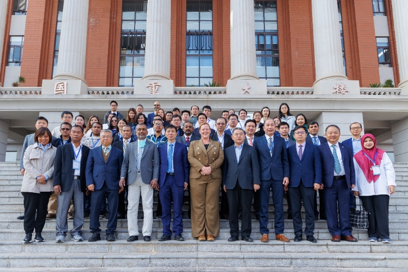
Participants of the high-level dialogue sessions of the forum
Source: Aerospace Information Research Institute of the Chinese Academy of Sciences

 Tel: 86-10-84097121
 Email: anso-public@anso.org.cn
 Location:No.16 Lincui Road, Chaoyang District, Beijing, China