
中文
-
About ANSO
-
News & Media
-
Members
-
Events
-
Programs
-
Publications
-
Get Involved
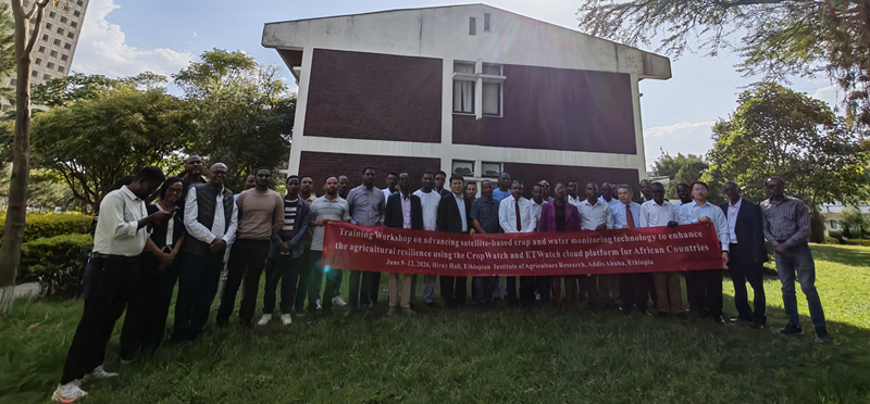
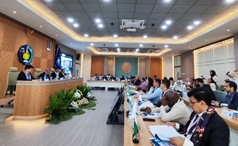
ANSO Training Workshop on Advancing Satellite-based Crop and Water Monitoring Technology to Enhance the Agricultural Resilience Using the CropWatch and ETWatch Cloud Platform for African Countries was held in Addis Ababa, Ethiopia from 9 to 12 June 2026. Funded by the 2025 CAS-ANSO Conference Program, the event was to help African participants develop their capacity in satellite-based crop and water monitoring, thereby enhancing regional agricultural resilience.
Organized by ANSO, in collaboration with the World Bank and the United Nations Conference on Trade and Development (UNCTAD), the training was jointly implemented by the Aerospace Information Research Institute of Chinese Academy of Sciences (AIRCAS), the Ethiopian Institute of Agricultural Research (EIAR), the ANSO Africa Hub for Science and Innovation (AAHSI), Ambo University, the Group on Earth Observations Global Agricultural Monitoring (GEOGLAM), and Ethiopia’s Agriculture Transformation Institute (ATI).
This workshop is part of ANSO’s flagship capacity-building series, which runs multiple sessions each year to deliver advanced agricultural and remote sensing technologies to developing countries. Although ANSO has regularly organized various training activities across Africa, this workshop was the first crop-monitoring training workshop specifically designed for East Africa, with participants from other African countries also welcomed. It attracted more than 50 technical personnel, researchers, PhD students and government officials from seven countries, including Kenya, Rwanda, Burundi, Tanzania, Somalia, Ethiopia, and Algeria, working in agriculture, water resources, meteorology, and related fields.
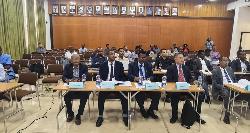
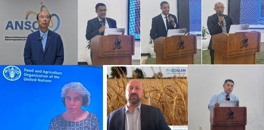
At the opening ceremony, remarks were delivered by H.E. Mr. Dessalenge Teshale, Ethiopian State Minister of Agriculture; Professor LIU Weidong, ANSO Executive Director (via video); Professor Nigussie Dechasa, Director of EIAR; and Professor Solomon Masho, Vice President of Ambo University. Subsequent keynote presentations were given by Mr. Michael Norton (World Bank), Ms. ZHANG Liping (UNCTAD), Ms. Livia Peiser (FAO), and Mr. Sven Gilliams (GEOGLAM Secretariat).
State Minister Dessalenge Teshale noted that agriculture underpins most African economies, yet limited agricultural output imposes severe pressures on farming activities across the continent. He emphasized that the CropWatch and ETWatch cloud platforms embody a joint commitment to boosting African agriculture via science, technology, and innovation. The platforms deliver actionable data to facilitate climate adaptation, drought risk mitigation, and sustainable resource management in East Africa for food security assurance. Prof. LIU Weidong pointed out that water scarcity and food insecurity have long stood as core shared challenges for East African countries. Intelligent monitoring systems built on satellite remote sensing are therefore in urgent demand to track crop growth, identify drought hazards at an early stage and quantify crop water stress. The two cloud platforms empower East African countries to develop data-driven, climate-smart agriculture and water governance frameworks, advancing progress towards United Nations Sustainable Development Goal 2 (Zero Hunger). Professor Dechasa expressed gratitude to ANSO for its financial support and for entrusting EIAR as the local host. He expressed the hope that technical expertise gained throughout the workshop would substantially advance the intelligent transformation and sustainable development of agriculture across East Africa.
All subsequent keynote speakers echoed this viewpoint. They noted that converting Earth observation data into actionable insights through user-friendly platforms such as CropWatch and ETWatch enables countries to lower technical barriers, develop self-sustained national monitoring capacity and strengthen long-term agricultural resilience.
As part of the opening agenda, Professor WU Bingfang, leader of the CropWatch team at AIRCAS, delivered a keynote presentation entitled “Democratizing Satellite Data Service: Introduction of the CropWatch and ETWatch Cloud Platforms”, elaborating on the core strengths and characteristic application tools embedded within the two cloud systems.
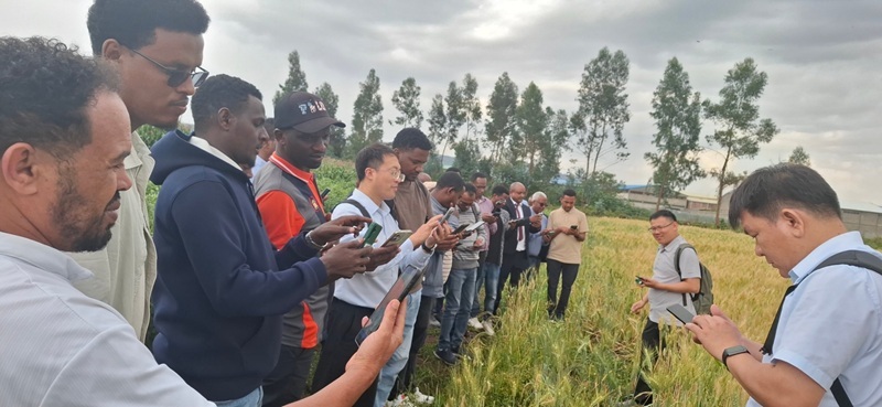
This four-day training workshop integrated theoretical lectures with hands-on practice. Its curriculum covered a full suite of core modules: basic operations of the CropWatch and ETWatch cloud platforms, AI application in agricultural ecosystem mapping, data preparation for analysis, field training using the GVG and CropWatch Farmer apps, thematic mapping of crop planting area, crop yield and total production, national-scale analysis, evapotranspiration estimation at both high and low resolutions, and the design of customized regional monitoring schemes.
To tailor the training to the on-the-ground demands of participating countries, a special National Profile Sharing session was arranged on the second day. Delegates from all participating nations shared their domestic agricultural characteristics and technical demands regarding crop monitoring. Drawing on the feedback, the training team refined follow-up teaching materials and case studies to deliver customized learning for all attendees.
This workshop reflects ANSO’s enduring commitment to empowering sustainable development across the Global South via science, technology, innovation, and capacity building (STIC). Beyond boosting participants’ practical proficiency in navigating the CropWatch and ETWatch cloud systems, the workshop fostered cross-border exchange and technical partnership across agricultural remote sensing disciplines. All delegates stated they would leverage this training as a foundation to advance deeper cooperation on crop monitoring, Earth observation data sharing, and related thematic work.
Moving forward, ANSO will expand collaborative research partnerships among research institutions throughout developing regions, translating state-of-the-art remote sensing technologies into implementable solutions for food security. Furthermore, this training initiative establishes a scalable, replicable template for South South cooperation to address climate-related risks.


 No.16 Lincui Road, Chaoyang District, Beijing, China
 86-10-84097121
 anso-public@anso.org.cn